Looking out over the sparkling waters of Biscayne Bay, graduate student Nathan Laxague is committed to helping researchers and the public understand how and where pollution is impacting the bay.
“Since we live in such a beautiful place with a gorgeous bay, we need to educate people about what happens when they drop things in the bay,” said Laxague, who is studying applied marine physics at the University of Miami’s Rosenstiel School of Marine and Atmospheric Science.
The collaborative community science project called the Biscayne Bay “drift card“ experiment (#BayDrift) studies how water moves to better understand how trash, sewage, oil, and harmful algae blooms flow through South Florida waters and are impacted by wind and ocean currents.
The Rosenstiel School designed the experiment to assist caretakers at the Vizcaya Museum and Gardens, who are looking for ways to mitigate the high volume of debris frequently deposited at its waterfront doorstep.
Vizcaya contacted Frost Science, who in turn contacted UM’s CARTHE (Consortium for Advanced Research on Transport of Hydrocarbon in the Environment) research team. The research team is using the same technology, modeling capabilities and world-class scientists who studied the impacts of the Deepwater Horizon oil spill on the Gulf of Mexico.
The team of scientists from UM’s CARTHE are tracking trash that accumulates in the bay, because they want to learn how the currents push the trash as it drifts and where it will end up. “If we track the trash over 24 hours we can determine when, why and where the accumulation of debris became larger and how it drifts gaining more debris and ends up, for example, at Vizcaya,” said Laxague.
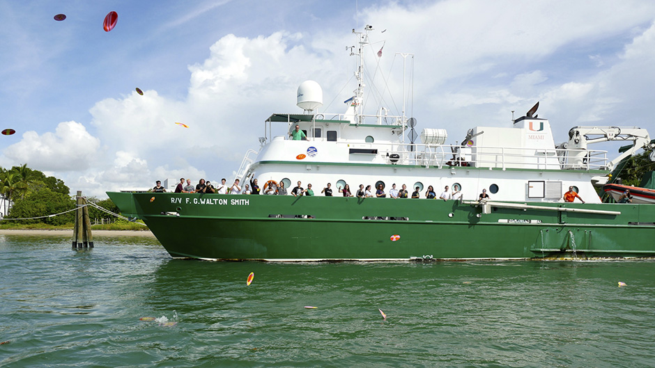
Recently, twenty-five students in grades 10-12 at nearby MAST Academy painted and cast their drift cards from the Rosenstiel School dock on Virginia Key. For the next ten months, the University of Miami-led project team will coordinate quarterly deployments of drift cards with scientists, students, families and members of the community in eight locations across northern Biscayne Bay near downtown Miami.
Drift cards are small, brightly painted eco-friendly wood cards that float along the water’s surface, moved by the currents. Each card is coded, to identify for the project team where it was deployed. Additionally, the drift cards are labeled with information that introduces the project and instructs the finder how to report where it was found.
“By tracking the location where drift cards are released and found, we will learn how the currents distribute debris in Biscayne Bay. We want to learn how the debris moves on its path, which is useful because the drift cards are numbered, and when they end up on shore their journey from point A to Point B can be mapped,” said Laxague. The school’s Helicopter Observation Platform (HOP) will provide an aerial perspective of the drifter paths and will sample carbon, wind turbulence and gas air-sea exchange, in relation to coastal interactions.
The local currents in and around Biscayne Bay play an important role in the health of the ecosystem and therefore the health and wellbeing of the community. The observational data collected during the Biscayne Bay Drift Card Study will create better computer models for predicting the transport of pollutants in Biscayne Bay, and provide answers to some basic questions such as where trash washing up on beaches is coming from, and why people should be concerned about pollution far from their homes.
Based on existing models and knowledge the eight deployment locations within Biscayne Bay include: Museum Park/Miami Science Barge, South Pointe Park, Little River, Miami River, Rickenbacker Causeway fishing bridge, and UM Rosenstiel School dock, and two boat-based sites near Star Island/Miami Beach and Miami River outlet. The model developed using the drift card data will be publicly available. The ultimate goal of the study is to advance our understanding and the science of the area’s flow patterns, and provide students and residents a hands-on STEAM activity (STEM + Art) demonstrating how the ocean and bay currents transport various substances.
“As a result of the currents, drift cards might be found anywhere along Miami-Dade County coastline and beyond. All of the information about where and when drift cards are deployed and recovered will be used by our scientific team to develop a model,” Laxague said.
The Rosenstiel School wants to help community partners and the broader Miami community understand how debris moves with the current to develop solutions that will decrease the trash and debris in Biscayne Bay and along shorelines. If you find a drift card, report the date, time, and location, along with a photo, via Instagram by using #BayDrift or email to BayDriftMiami@gmail.com.